SityTrail - Jesus Trail - Golani Junction-Arbel SityTrail > Trails > Outdoor > Israel > North District > Unknown > Galil Tachton Regional Council SityTrail > Trails > Outdoor > Israel > North District > Unknown > Galil Tachton Regional Council SityTrail - Jesus Trail - Golani Junction-Arbel waesberghe User 3D © OpenStreetMap contributors Length 21 km Max alt 315 m Uphill gradient 375 m Km-Effort 26 km Min alt -86 m Downhill gradient 549 m Boucle No Creation date : 2019-02-09 11:05:19.832 Updated on : 2019-02-09 18:12:57.731 (0 Reviews) Walking 24h26 Difficulty : Very difficult FREE GPS app for hiking SityTrail IGN / Geographical institutes SityTrail World The world is yours! About Trail Walking of 21 km to be discovered at North District, Unknown, Galil Tachton Regional Council. This trail is proposed by waesberghe. Legends | More details (PDF) Elevation profile Legends > 15% 15% - 10% 10% - 5% flat 5% - 10% 10% - 15% 15% - 30% > 30% Positioning Country: Israel Region : North District Department/Province : Unknown Municipality : Galil Tachton Regional Council Location: Unknown Start:(Dec) 32.774954 / 35.407053999999995 Start:(UTM) 725454 ; 3628903 (36S) N. Comments Please log in to post a review or rate the element Trails nearby waesberghe SityTrail - Jesus Trail - Golani Junction-Arbel Walking Very difficult Galil Tachton Regional Council, North District, Unknown, Israel 
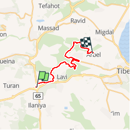
39 km | 50 km-effort 24h 26min No waesberghe Jesus Trail - Golani Junction-Arbel Walking Very difficult Galil Tachton Regional Council, North District, Unknown, Israel 17.3 km | 22 km-effort 4h 41min No